
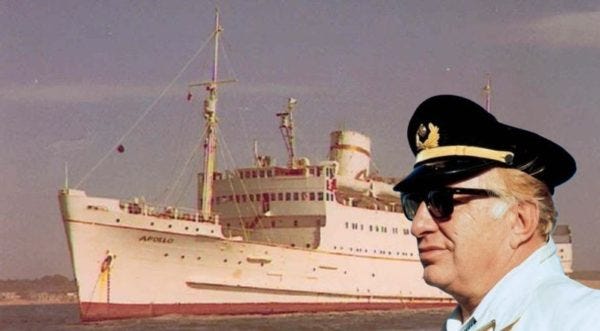
Val Ross was telling us about this lecture by Scientology founder L. Ron Hubbard, which he gave aboard the Royal Scotman (later the Apollo) to his Sea Org crew in 1968. It formed the basis for the book Mission into Time, but the lecture is more immediate, and more personal.
Hubbard was reporting to his followers about his attempt to prove his “whole track” memories — the memories he had from previous lifetimes. To test them, he sailed to several places in the Mediterranean, telling his crew that he could remember details from ancient Sardinia and Sicily, and he asked his crew to check them out, to confirm that what he was remembering was real.
We think it’s a fascinating artifact that captures Hubbard at his most fanciful. And what do you think? Was he really remembering ancient locations, or was he convincing his crew to see what he wanted them to see?
We have just completed a very successful cruise on the Sea Org Flagship, Avon River, which lasted for some five weeks or so. When I go on a cruise people get curious as to what it’s all about and, perhaps, would like to know something about it.
The cruise had several purposes and one of these was a test of whole track recall.
People fool around with this and think they were Julius Caesar, and then in a spin-bin you can find Cleopatra and Christ. It seems like the only lives they lead are the ones you find in the Encyclopedia Britannica. Because of this whole track recall to some degree tends to become invalidated.
An invalidation is fairly serious since the road out also includes very good recalls. So, not that I needed it proven particularly as a matter of fact, I thought we would just make part of our operational schedule a check up on whole track recall.
We played a sort of a game. The Sea Org, as you know, has many types of missions so we made this up into a mission type game.
What I would do is write it all down and then we would call a final object a target. With Sea Org efficiency we would organize it across the organizational divisions. The boats would take off and parties would go and check to see if they could locate the target. They would see whether or not the whole track recall situation was at all interesting or if it was there.
This wasn’t the only purpose in our five weeks cruise. One of them was to check up on bases. Another was to sound out about various political scenes. We had a lot of things to do.
We played this game rather consistently straight through. Writing up an area we’ve never been into this lifetime, saying exactly what the score was with regard to that area and then sending our parties to see if they could locate and estimate whether or not these recalls were exactly correct. And this we did.
There are five in all that we will describe here.
This cruise, of course, is an interesting item in itself. You can read about cruises in travel magazines. “We set sail in the ghastly dawn and into force eight wind. As we sailed along peacefully with our topmast blown out, we were eaten by a monstrous whale. The First Mate brought a puppy aboard whose name was Ginger …. ”
It’s all good stuff you know, but we don’t happen to be writing for a travel magazine right now and we simply assume the Sea Org when it pushes a ship to sea knows its business. That the ship crosses water, that the engines sometimes with some difficulty drive the ship forward, that conditions get assigned and we eventually arrive at the destination and do what we’re supposed to do there. Sail on schedule, sometimes leaving members of the crew behind, carry on our happy nautical way and return back from where we came from all in one piece.
So I will omit the nautical details and refer you to yachting magazines, old sea stories or the annals of space opera, and we will go at once to the point.
The first of these targets was in Sardinia and was the ancient city of Nora, a Roman-Phoenician city which perished in the second or third century AD. This city was on the South-east corner of the island and the difficu1ties involved in the situation were archaeologists.
Some people can take dirt or leave it alone, but an archaeologist has to maul it about. He has a thing on bricks, you see, and he has to sort things out to find out if this brick is older than that brick. “If this brick is older than that brick the women of Nora, of course, naturally, wore high heel shoes.” Well anybody could have told him that.
Actually what they do is when they do the “put-together” they have somebody along who has been there before and who has some dim recall. So he reconstructs it all “scientifically” as near as I can figure out. They make a lot of mistakes because they don’t do it with an E-Meter. Not scientific at all. Then they write up a bunch of lies in some history book and give you a bunch of wrong dates so when you study history you practically spin as a kid.
So, these archaeologists have been at Nora and it looked like they’ve been trying to bury a bone or something of the sort.
The target involved in the situation was way back when.
I should be very careful of this sort of thing. My reputation is always at stake. There are tremendous numbers of people around who keep telling you, “Ron ought to be this and that.” My only answer to it is, “Ron is!” My sins are probably no greater nor less than anybody else’s, but I often wonder if they sometimes weren’t more boring (also sometimes in some places more interesting). I missed all the high points people were supposed to have on the whole track such as being Julius Caesar.
Ask somebody who is really spun on his whole track memory. First he was Alex and then he was Julius and then he was Jesus, coming on down the track. There are reasons for this. These guys, of course, cave somebody in so they read on the meter. One’s history gets mixed up because valences get mixed up. When you start straightening this thing out you get a pretty good idea of who you were and why.
Anyway, I was over in Carthage around the second or third century BC. I was operating there with the Carthaginian fleet.
There’s a gag in back of this. Nobody was ever promoted in World War II who was in a battle zone. When I’d been passed over for promotion (by reason of physical disability to do what I was engaged in doing) my crew once presented me a commission and it said, “Phoenician Navy 1,003 BC.” That’s very funny because it’s almost true.
I used to have a pretty good time around Carthage, nice sailing water and so on. About 200 BC I knew a girl in Nora. (It wasn’t called Nora then.) I knew this girl over there and she was the current Goddess of Tanit. She was a good looking girl. We had a lot of girls in Carthage but they didn’t come up to her!
So I used to sail across the straits there. “The Canal” they called it. I used to sail across to Sardinia. When I was going to Greece with the fleet, why, somehow or other it detoured via a point to the west of where we ought to be going and we seemed to fall at Nora. When we were going along the African coast it was always easier to go via Nora. Officers used to tease me about this. They seemed to think that all navigational patterns ran through the town of Nora.
It was usually a good thing I called in there with a war vessel because it was a matter of almost war. The girl would say, “Hey! How are you?” and all the other guys wouldn’t have a chance for a while. If you’ve got enough war vessels and you’re making enough dough, well, girls usually say this. She threw all the local swains over the hill and ARC broke everybody in the place. I probably could have had more duels than sunrises, because this was quite a girl.
There was a secret entrance to the temple and on the off chance that the archaeologists hadn’t discovered it (it looked like it wasn’t an entrance), I drew up the plans.
When we arrived in Sardinia we first went up to the south-east point of the island according to the map. I had too much data. It’s the first time in my life I had ever seen a map of the place. Really wild! I mean, like, here was a map. So this is the entrance of new data I had never seen before. Here was a map and it shows the southeast corner of Sardinia in a most available point.
We sailed to the southeast corner of Sardinia and looked all over the place. There wasn’t any basis to anything. I got completely lost and wondered what the devil we were doing. All of a sudden the “Enchanter” that had been on scout came back and said, “Hey, this isn’t the southeast corner of Sardinia. The southeast corner of Sardinia is down there. There’s an old Roman City buried down there like you said. Only this isn’t the southeast corner of Sardinia. That was very illuminating.
So we promptly went down there and we laid our eyes on the Temple of Tanit as a ruined platform. Messengers and missions were sent ashore to lay a map of the area to see if they couldn’t discover this old secret entrance to the temple as the target and demonstrate the whole track memory.
We did just that. We lowered boats and rowed back and forth. We sent people ashore and they looked it all over and finally came up with a result.
Now I’m going to call on Hana Eltringham to tell you whether or not that was a positive result.
Hana Eltringham:
That most certainly was a positive result. We found the base of the old temple right on top of the hill. It was built on a piece of land jutting out into the sea and it had water on three sides of it.
There was the platform, right on top of this small rise. The foundations were there. It was all oblong like it should have been, and over the north of it we did find the tunnel. It looked like a ditch about six feet deep, about fourteen feet long and about four feet wide. It led from the side of the rise right up next to the foundation of the temple but not on the same level.
We scraped around the bottom of the ditch and we found that it was tiled underneath, covered with dust and dirt. Going up right to the top of the ditch we found a few rocks and so on, which formed a kind of wall against the temple.
We kept on digging here until we were quite convinced that this was the ditch that led into the basement of the temple. So that was totally proven and totally accurate.
So this one was positive. I heaved a few sighs over the fact that the girl wasn’t still there, but on to our next adventure which was infinitely later in history.
II
We went over to Sicily. When we got there it was very remarkable to look around because Sicily had been very hammered and pounded and chewed up. It is also full of ancient ruins.
In this particular instance the target we were interested in was a Roman graveyard and an ancient tower. The longer I was there, the more just being in the area, the more memory returned. The primary target was the tower. The Roman graveyard was kind of hard to identify because someone had made a stables out of it. Aside from that we were looking for this ancient tower and for a cellar that went into the side of it.
I wrote all this up long before we got there and said this is the way it would be. You’ll find so and so, and so and so.
When we arrived at that point we sent missions over on the beach. They looked around and identified the various objects.
Now I’ll call on Craig Defan who was on that mission to give his comments on the results.
Craig Defan:
Again positive.
We were given a map about two days before we went to the tower. The map simply showed a bay area giving the distance that it would be away from the tower and where the beach would be and how the bay area would look.
We travelled for about a day and a half and there was the beach as was mapped out. Before we got to the tower there was another map with exactly the plan of the tower, how the tower would look, how the cellar would look and its whole construction.
We left the ship, went to the tower, dug around for several hours, found exactly the structure that was indicated. It was positive, and that was that mission.
III
It is interesting that the ancient world, you know, was totally over populated. The thickness of population to their ability to organize and manage was many times greater than the thickness of population in the now known world. People overlook this.
Sicily had, for instance, 160 huge cities. Its population today is probably not a tenth of that. Sicily was dead before the first century BC. It had already been knocked to pieces. The Greek and Carthaginian occupation and the various quarrels across this island were such that civilization almost ceased to exist before the Romans really took any part of it.
The ancient world, of course, had the problems of over population which resulted in slavery, which resulted in excessive cruelty and which resulted in war, an effort to conquer more land to feed their people.
It was rather interesting to see the barrenness and the desertedness of these ancient cities. the whole of the civilized world at that time and its density of population has not in actual fact been understood fully. You’ll see the city ruins one right after the other, city right up against city and the archaeologists scrambling around in the dirt trying to bury a bone, I think.
Laying bare these things gives you some distorted; weird ideas. I don’t know where he gets his population estimation. Maybe he gets them from the size of armies. He said the Greek Army, 36,000 strong, was sent to the support of the cause of Syracuse. They had 136 ships and a 36,000 man army.
What he doesn’t include in the statement is, a fighting man as a soldier is a number in that 36,000 and every one of those fighting men had about five people on his logistics line. So you see he didn’t have a 36,000 man army, he had five times 36,000 and they are heavy numbers.
In World War II I think there were only a quarter million of us fighting the war and we had four and a half million people in bases stateside messing up our logistics.
Another time you’d go out as the Sixth Fleet or the Seventh Fleet and you would find it was the old Fifth Fleet you were just in.
The point I am making is the archaeologist makes a fundamental and fantastic error when he counts the number of soldiers engaged in the battle. He omits the number of supply sergeants, clerks and of course “supper generals” who are sitting back of the lines and there are thousands of those.
Like the private who got scared. He ran and ran and ran and finally fell down. He got up and found himself looking at a beautiful pair of boots and somebody said” “Here, my man, what regiment do you belong to?” The private stammered, “13Sth.” The voice said, “Well my man, I’m your colonel,” and the private said, “My God! Am I that far back!!!?”
So in point one of the various means they use to estimate population is the number of soldiers in the army. These are not reliable figures.
You go out there and look at the mountains of Sicily and you find the old terracings and so on. These are all deserted and everywhere you look you find nothing but deserted ruins. There’s nobody living there today. They are pressed into a city half the size of one of the ancient cities and rest of the country is deserted.
The problem of the world by the way is not a problem of overpopulation. It’s a problem of bad management. That was the basic problem of the ancient world. They never solved the problems of agriculture.
I had a lot of fun looking around Sicily. It’s funny to look at the stuff after the fact.
We sailed on to the mainland of Italy as we had something else to do and finally we sailed back around Sicily to Tunisia.
The first time we stuck our nose out we got it wiped but good. Just as we left our anchorage, a piece of cake, flat calm we no more stuck our nose out than a blow hit with such suddenness that it was fantastic. We hauled back into a port there and waited the blowout. Then we went on across the straits.
Before we got over there I gave them a description of the target. It was in the city of ancient Carthage. This was all drawn up and so we headed for Carthage.
When we got into the harbor at Tunis, however, I looked up and I said, “Good golly. There is the old symbol of Carthage.” It is one of the mountain shapes there and I turned around and described this fact. I looked at where Carthage is. The target I gave them was, of course, Roman Carthage, but I said ancient Carthage used to layover there on the other side of that peninsula underneath that mountain.
I didn’t think any more about it. That was old Phoenician Carthage and that wasn’t our target. Our target was Roman Carthage.
After Rome conquered Carthage they built another city in its place regardless of what they say in the history books. The Arab now has Ancient Carthage. He has got so many ancient civilizations that he doesn’t care much for them and he doesn’t take much care of them. He’s fairly happy-go-lucky.
Anyway we formed up this mission at the beach and got this target all arranged and sent a party over to see whether or not the target was still there. I’m going to call now on Van Lewis to tell us whether or not the target was still there.
Van Lewis:
I don’t think you’ll be surprised to learn that the target was still there. We went to the area which the Commodore indicated. He had made a small clay mockup and the mission members checked this over very carefully before going out.
The clay mockup had two mountains to the northeast and an area of mountains or hills to the northwest. It had an area of old dockyards to the southeast and an area of four ruins from the west to the northwest of the target. The target was located on the western to the southwestern side of the hill.
After a few days of looking over the area, the members of the mission began to wake up and to see what was there.
We found that there were four areas of ruins, just as indicated on the mockup. So we returned to the ship and took a more careful look at the mockup and returned to the hill. We found that those four areas on the mockup were in the precise relationship to each other and the surrounding area as on the mockup. So returning to the ship again and taking a more careful look at the mockup and returning to the hill it was found that the largest lump of clay on the mockup board represented the largest area of ruins.
After this was noted I felt pretty certain that we were somewhere close to the right area of the target. Going to the hill, we did manage to locate the southwest side of the hill. For the exact location of the target which was fairly small, there was a trifle bit of uncertainty yet remaining. There were supposed to be some underground structures and it’s difficult for me at this time to see underground, so I’m not sure, but we do think that we had this located within a 40 yard square, and perhaps very much closer than that.
A very definite positive on this mission also.
What’s amusing there is, you give the Mediterranean people two stones and they promptly make a building. The whole areas of ancient Carthage is completely built over with modern apartment houses, asphalt roads and everything you can imagine. This mission was having enormous trouble trying to pick up from the new structure the old foundation and they managed to do so.
Another humorous note. Just as we were leaving, we had asked for some sort of license to lie off the coast. You always have to have a piece of paper. We asked for this and we sent over an Arab interpreter of ours, Mestasi. He got confused about the whole thing and said we were going to go under water. So when the head of the Bureau there asked, who wanted to go under water, he said, well, his father did. He blew up at that point and so we got a visit from the head of the Oceanographic Institute.
These people were very confused and they tried to tell us we must not go off the coast and do any diving, because If we did any diving they would have to confiscate the ship.
I thought that was very interesting. They could give us a piece of paper to permit us to dive but the thought of us diving made them very upset. I thought, “What the devil is underwater around here that’s so interesting to dive for?”
We cross queried all of this to get an explanation of what this was all about and it became very elementary indeed. They had discovered an ancient city underwater where I had indicated was the site of ancient Carthage. It’s down there intact.
That government is scared stiff somebody is going to come along and loot the place or something, because it is untouched by archaeologist’s hands. It’s just under the seas.
The point being that I’d never heard of it and I don’t believe anybody else had. The Government was keeping it some kind of dark secret until asked for a complete explanation. (We can’t tell anybody because it’s a secret but the reason you can’t dive is that there’s an ancient city down there.)
About that time we finished our other business in numerous areas and we started for home. In view of the fact that we would have arrived at some ghastly hour like 10:00 at night and you can’t enter the harbor out here in the dark (pilots don’t work in the dark), what I did was I wrote them up another target which was down the coast from where we were.
“We’ll slide down the coast, wait for dawn and we’ll check up on this target. As soon as we’ve checked it and taken a photographic check of the thing we’ll be on our way for Valencia.” So we slipped on down the coast and as the ship was lying there, I told them, “Your ship’s bow is now pointing at a pointed hill in a cove on the east facing side of the bow and the boulder there … etc.” We just lay there till dawn and then took a look and I will call on Lieutenant Howie to give you the results.
Lieutenant Howie:
Well, we got up in the morning early and went up on the bridge. The Commodore came up with the binoculars and we all started looking. The night before he told us the bow was going.to be pointed at a pointed peak on the east side of this cove and there would be a boulder on top of it. We started looking around and there was a pointed peak on the east side of the cove with a boulder on top of it.
To get a better look at it the ship was manoeuvred. We proceeded to pull the bow in the large cove. There’s a little cove inside of it on the east side and this little peak was sticking up from there. To get all different angles of pictures we put the bow in, backed it out, came along side, then backed in, which was a bit of a strain.
We’ve got the pictures and everyone saw the target and there was a boulder. It was exactly where it should have been and all night long we’d been sitting with Avon’s bow facing it. So it was a definite positive, from the night before.
Well, of course, these are all areas that I’ve never been in in this lifetime. They stretch back over some time and I’m shorthanding the history that goes along with some of these places. A lot of it is far, far too risque.
This was just one phase that we undertook in this trip and it made a very interesting side game. “It was there so many hundreds or thousands of years ago. It should be there now. Is it?”
We therefore should try to draw some kind of conclusion. I’m now going to call on Sandi Mehr to give us her idea of it. She was on most of these missions and she probably has a very good idea. Let her express her frank opinion.
Sandi Mehr:
Yes, I was on just about each of these missions that we sent out as each mission was a part of our whole mission which was our five week journey.
As Ron said, “Is it there?” Yes, it’s there! As a whole Ron wanted to know is the recall correct? The recall was correct. That’s all.
And now as a final witness on the matter, I want to call on Warrant Officer Yvonne Gillham. She was on nearly all of these and almost missed the ship.
Warrant Officer Yvonne Gillham:
Yes, what Ron says is true in every case. As Hana said, “There was the ditch!!” And, “There was the temple!!”
Ron would do the little clay models for us and he’d say, “Well, now there will be two hills here and on this side you’ll see a temple.” Sure enough, we’d go over and there would be two hills and there on the left side would be a temple.
Then he’d say, “On this hill there will be a tower.” And we’d go along and sure enough there would be the tower!!! If you weren’t sure you would just go back to the model again and you’d have the mountains in a certain direction, the coast line coming down here. You’d go along to this area and there would be a coast line here. You’d look out for the highest peak, that one which was the closest to Ron’s model. It would be that one. You’d go over there and sure enough all the coast line would be exactly as the model!! The mountains fell just as he said it was, it would be north to east.
It was very easy We just followed his models and followed his drawings and we’d hit the target. It was like that all the time.
There’s the sum of the story
There were lots of things funny that happened on this trip, lots of amusing aspects, quite a bit of adventure and we weren’t loafing about. We also had a lot of things to do to keep the ship running.
A lot of high points occurred. We found. out that motor boats that we’d always had trouble with in the past were unnecessary. Our little sail boats went along just great.
We had the usual number of close calls, except for the one that Bill Howie described about putting the ship forwards and then backwards in this little, tiny indentation in the cove.
It needn’t have caused the fright that it gave Hana, who was Captain then, because I had it under perfectly good control. If we’d had a couple of extra coats of paint on, it would have been a different thing. But our bottom paint had been wearing thin so we didn’t touch bottom.
All in all we had an awfully good time of it.
— L. Ron Hubbard
Want to help?
Please consider joining the Underground Bunker as a paid subscriber. Your $7 a month will go a long way to helping this news project stay independent, and you’ll get access to our special material for subscribers. Or, you can support the Underground Bunker with a Paypal contribution to bunkerfund@tonyortega.org, an account administered by the Bunker’s attorney, Scott Pilutik. And by request, this is our Venmo link, and for Zelle, please use (tonyo94 AT gmail). E-mail tips to tonyo94@gmail.com.
Thank you for reading today’s story here at Substack. For the full picture of what’s happening today in the world of Scientology, please join the conversation at tonyortega.org, where we’ve been reporting daily on David Miscavige’s cabal since 2012. There you’ll find additional stories, and our popular regular daily features:
Source Code: Actual things founder L. Ron Hubbard said on this date in history
Avast, Ye Mateys: Snapshots from Scientology’s years at sea
Overheard in the Freezone: Indie Hubbardism, one thought at a time
Past is Prologue: From this week in history at alt.religion.scientology
Random Howdy: Your daily dose of the Captain
Here’s the link for today’s post at tonyortega.org
And whatever you do, subscribe to this Substack so you get our breaking stories and daily features right to your email inbox every morning.
Paid subscribers get access to a special podcast series…
Group Therapy: Our round table of rowdy regulars on the week’s news
“Ron is!” a bloviating dopehead with a penchant for Rum, pinks, greys and whatever else he could lay his hands on.
It would be interesting to hear if, for instance, Hannah Eltringham recollected it any differently today?
You can imagine what would happen to any of those True Believers if they stood up and said "No, Ron is full of shit. There are tons of dirt over the features he described, and nobody can see through dirt."
That, Ron, is why real archaeologists have to dig to find things. Over time layers of dirt cover them.
There is also a little problem with coastlines. The sea level was quite different thousands of years ago. Some coastal features of the ancient world are now far inland, and others are underwater. Drawing a map from a thousand-year-old "memory" of a coastline will almost always be very wrong.
Hope some of those who were actually there will pop in and set the story straight. But as far as I know from some of the eye-witness stories I've heard, the "Mission Into Time" was a complete flop.